- 5 Posts
- 31 Comments
get_flomped@lemmy.worldOPto Selfhosted@lemmy.world•wanderer v0.15.1 - now with even more 3D and integrationsEnglish1·4 months agoThanks, I found it: https://git.dryusdan.fr/Dryusdan/garmin-to-fittrackee
I’ll check it out!
get_flomped@lemmy.worldOPto Selfhosted@lemmy.world•wanderer v0.15.1 - now with even more 3D and integrationsEnglish1·4 months agoThank you very much! Really appreciate the kind words :)
get_flomped@lemmy.worldOPto Selfhosted@lemmy.world•wanderer v0.15.1 - now with even more 3D and integrationsEnglish1·4 months agoUnfortunately Garmin does not offer their API to private consumers: https://developer.garmin.com/gc-developer-program/program-faq/
I have not found a way to pull the data without API access.
get_flomped@lemmy.worldOPto Selfhosted@lemmy.world•wanderer v0.15.1 - now with even more 3D and integrationsEnglish2·4 months ago
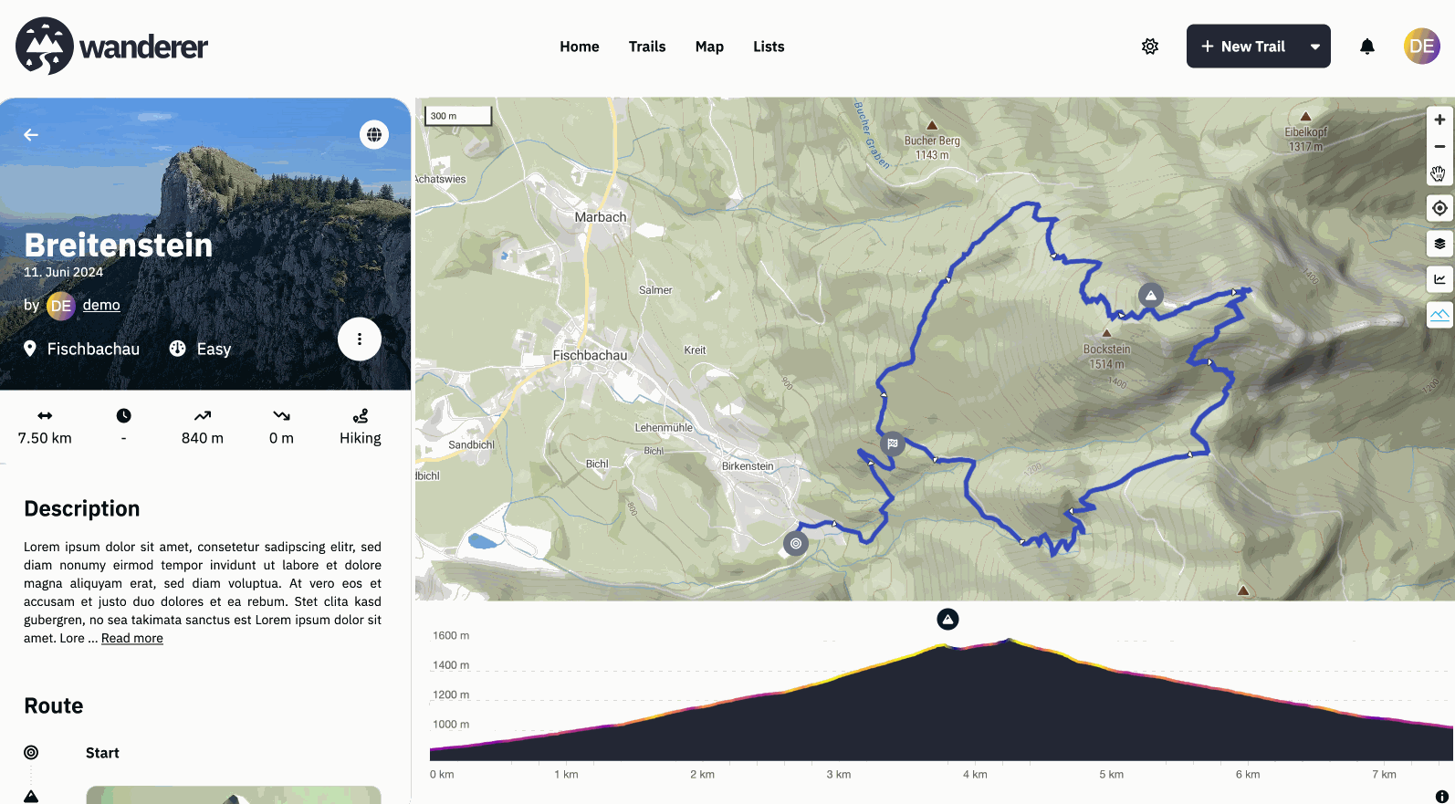
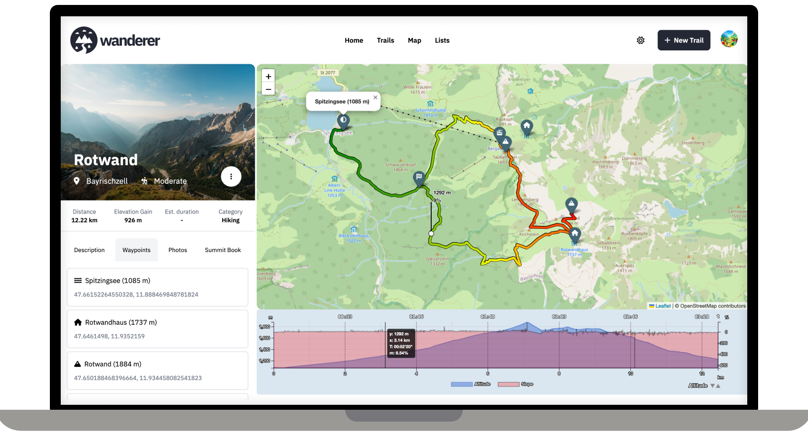
Recording is currently not possible with wanderer itself. I personally use osmAnd to record my trails and import them into wanderer. If you don’t want to expose wanderer to the public your friends would need to send you their trails, yes. But I guess that’s no different with any other service.
get_flomped@lemmy.worldOPto Selfhosted@lemmy.world•wanderer v0.10.0 - a self-hosted GPS track databaseEnglish1·7 months agoYes, bulk imports are supported. You will need to download them from GOSLogger first though.
get_flomped@lemmy.worldOPto Selfhosted@lemmy.world•wanderer v0.10.0 - a self-hosted GPS track databaseEnglish3·7 months agoCurrently no. I really like Dawarich for this purpose and I feel like I wouldn’t be able to add much.
get_flomped@lemmy.worldOPto Selfhosted@lemmy.world•I updated wanderer (v0.6.1) - a self-hosted trail and GPS track databaseEnglish1·1 year agoAh yes, sorry, the upload is currently capped at 5MB. You can change that limit in the PocketBase backend. I will add a guide to the docs.
get_flomped@lemmy.worldOPto Selfhosted@lemmy.world•I updated wanderer (v0.6.1) - a self-hosted trail and GPS track databaseEnglish2·1 year agoHappy that you got it working. What exactly does not work with the photos? Fell free to open a GitHub issue, if that’s easier.
get_flomped@lemmy.worldOPto Selfhosted@lemmy.world•I updated wanderer (v0.6.1) - a self-hosted trail and GPS track databaseEnglish1·1 year agoI really love working with PocketBase. It gives you such a headstart, but also is highly customizable. It’s really the best of both worlds.
get_flomped@lemmy.worldOPto Selfhosted@lemmy.world•I updated wanderer (v0.6.1) - a self-hosted trail and GPS track databaseEnglish3·1 year agoI don’t know the app. But on the linked page it says it supports GPX and KML. Both of which wanderer supports.
get_flomped@lemmy.worldOPto Selfhosted@lemmy.world•I updated wanderer (v0.6.1) - a self-hosted trail and GPS track databaseEnglish3·1 year agoExactly! As long as you have the track in a GPX, TCX or KML file, you are good to go.
You can also plan your route directly on wanderer (so you don’t fall off another cliff ;))
get_flomped@lemmy.worldOPto Selfhosted@lemmy.world•I updated wanderer (v0.6.1) - a self-hosted trail and GPS track databaseEnglish2·1 year agoThanks! No this is an extremely low spec server: 2GB RAM and 2 virtual cores.
get_flomped@lemmy.worldOPto Selfhosted@lemmy.world•I updated wanderer (v0.6.1) - a self-hosted trail and GPS track databaseEnglish1·1 year agoOr use the demo ;)
get_flomped@lemmy.worldOPto Selfhosted@lemmy.world•I updated wanderer (v0.6.1) - a self-hosted trail and GPS track databaseEnglish11·1 year agoCool! I always recommend OsmAnd.
get_flomped@lemmy.worldOPto Selfhosted@lemmy.world•I made wanderer - a self-hosted trail and GPS track databaseEnglish16·1 year agoWith docker you can simply change the port mapping in the compose file
get_flomped@lemmy.worldOPto Selfhosted@lemmy.world•I made wanderer - a self-hosted trail and GPS track databaseEnglish3·1 year agoThat’s strange, I never had that happen. If you have the time could you please open an issue on GitHub?
get_flomped@lemmy.worldOPto Selfhosted@lemmy.world•I made wanderer - a self-hosted trail and GPS track databaseEnglish4·1 year agoAbsolutely all help is welcome. Please check out the roadmap for my current plans. I’d be delighted if you could add your Dutch translation here: https://translate.codeberg.org/projects/wanderer/wanderer/nl/
Dank je wel!
get_flomped@lemmy.worldOPto Selfhosted@lemmy.world•I made wanderer - a self-hosted trail and GPS track databaseEnglish4·1 year agoSpeed statistics were added in v0.2.0. Hopefully also with some bugfixes.
get_flomped@lemmy.worldOPto Selfhosted@lemmy.world•I made wanderer - a self-hosted trail and GPS track databaseEnglish3·1 year agoOffering print support for trails is high on the priority list.
Have a look at the demo site. Everything is set up there already. I personally use the generous free tier of MapTiler.