

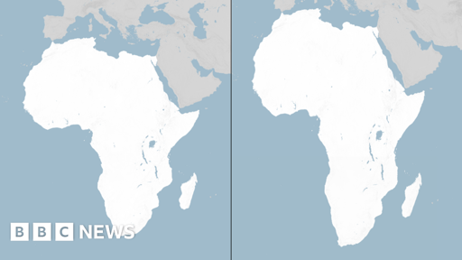
The UN General Assembly has voted to replace the traditional world map with one that more accurately reflects the size of Africa.
The “Correct the Map” resolution, sponsored by Togo and backed by African Union (AU) members, passed with the support of 164 nations, including France and the UK. The US was the only nation to vote against it - while there were six abstentions.
The UN vote is non-binding but will see changes to the maps used by institutions around the world.
Projections of the earth on a flat plane is one of those “theres more than one way to skin a cat” type of things
The mercator projection became the standard because its math makes all rhumb lines straight on the map, which is helpful for maritime navigation. But the sizes of countries are out of whack.
The UN logo is itself actually an alternate projection called the azimuthal equidistant projection, which is a projection where all the lines of longitude are straight instead and everything is accurately proportionally distant from the pole. It’s also favored by some due to it showing all the continents other than Antarctica without a split in the Pacific ocean. More of a global perspective rather than eastern vs western “hemispheres”
The new equal earth projection is similar to the mercator but does not make straight rhumb lines, so everything is proportional. When we decide how to represent the earth on a flat map there is always some kind of emphasis on one thing or another to make it most useful in some way. Given that most navigation is now done via GPS, this new standard map is one that has more political importance versus practical/functional importance in its design
I knew most of this except this is the first I have heard of a ‘rhumb line’. Did someone misspell thumb line along the way?
Jokes aside, are they changing the type pf projection being used or are they just changing africa in isolation as a polical stunt?
The article tells you if you read it